 Banff City Guide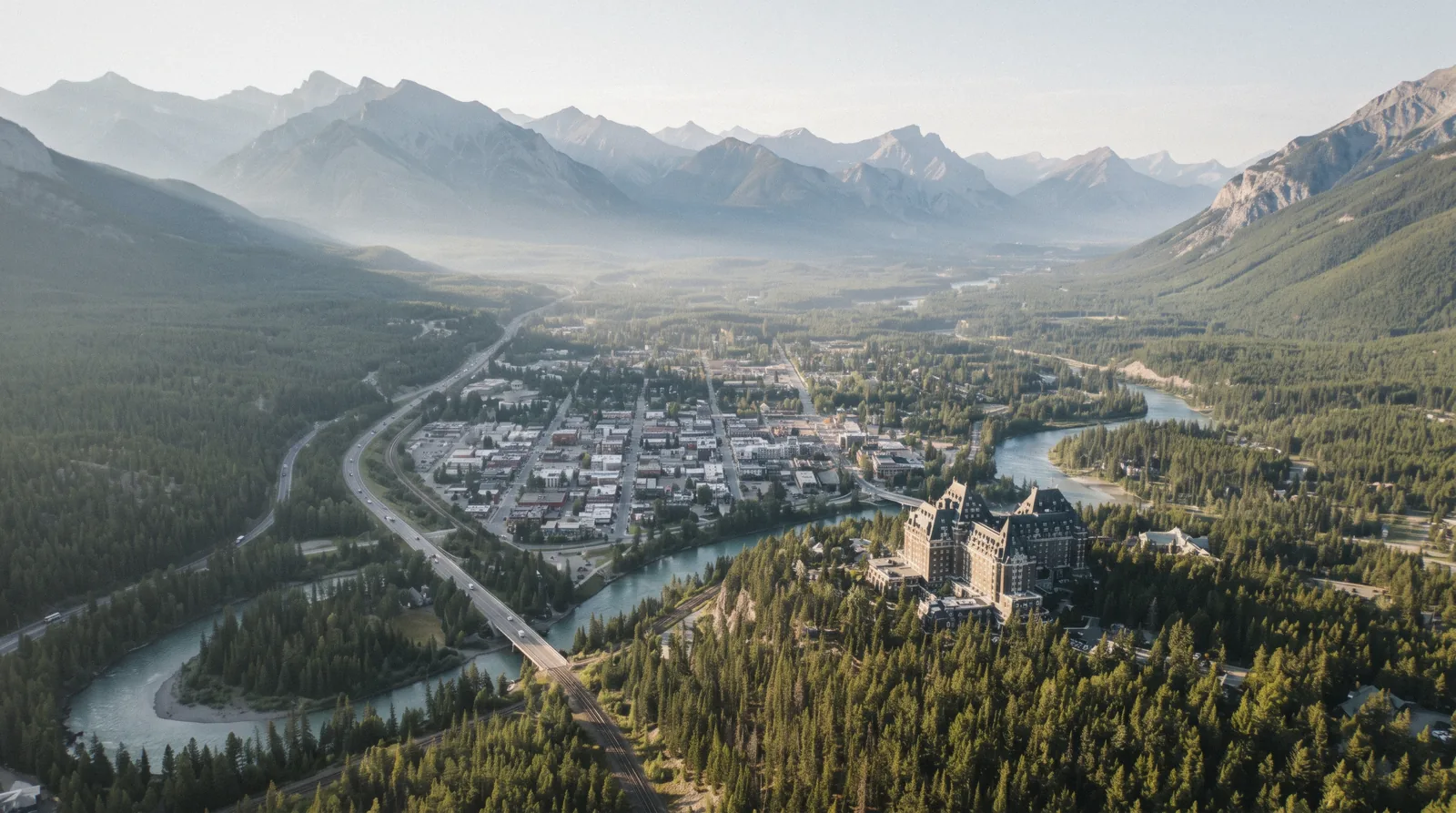
Banff Map: The Town and the Valley, Pinned
This Banff map pins every stop that matters in the valley, from the townsite at 1,383 m to the canyon trailhead 25 km northwest. Group the pins by area, check the drive times, then read what to see in Banff to rank them. The whole valley, start to finish: the Banff homepage.
Quick answer How to use this Banff map
Banff is small and the valley is long. The townsite sits in the Bow Valley at 1,383 m, with most downtown pins walkable from Banff Avenue, the gondola and hot springs 4 km south on Mountain Avenue, the big lakes 20 to 40 minutes northeast, and Johnston Canyon 25 km northwest on the Bow Valley Parkway. Plan the town pins on foot and the valley pins by car, Roam bus or tour.
Key takeaways
- Downtown pins cluster around Banff Avenue, the river and the two museums. Park free at the Train Station lot and walk. See our Banff walks page for the foot routes.
- Sulphur Mountain holds three pins: the gondola base, the summit and the hot springs. Route 1 links all of them to downtown, and gondola ticket holders ride free. Compare tickets on the gondola admission page before you go up.
- The Lake Minnewanka dock is a 20-minute drive from town by the operator's own wording. In summer the Lake Minnewanka cruise is the only boat tour allowed on the lake, and Roam Route 6 carries ticket holders free.
- Johnston Canyon sits 25 km northwest on the Bow Valley Parkway. If you have no car, a Johnston Canyon day trip covers the drive.
- Moraine Lake Road is closed to personal vehicles year-round. Any map app that routes you there is wrong. Read the Moraine Lake page for the shuttle options.
The Interactive Banff Map
The map below centers on the townsite at 51.1784 N, 115.5708 W. Pins use the exact coordinates published for each place. Zoom in for the downtown cluster, then zoom out for the lakes and the ski hills. Colors group the pins: dark green for the town, blue for water, grey for mountains and rides, brown for heritage sites.
The Pins, Numbered and Grouped
Twenty pins cover the valley. Below they are numbered and grouped the way you would actually visit them, with what each pin is for and how it links into the transport network. Drive minutes are our estimate unless the figure comes from an operator. The figures quoted here come from Parks Canada pages, the Town of Banff, Roam Transit and the official operator sites.
Downtown and Riverside Pins
These six pins you can do on foot. The townsite covers only 3.93 square kilometres and the downtown grid runs along the Bow River, so nothing here is more than a short walk from Banff Avenue. Free 9-hour parking sits at the Train Station lot with about 500 stalls, plus 94 free spaces on Bow Avenue and the free upper levels of the Bear Street Parkade.
If you drive into the pay zone instead, it costs $8.52 (C$12) per hour (about $8.52) from May 1 to October 31 and $4.97 (C$7) from November 1 to April 30, enforced 8 am to 8 pm daily. The numbered pins: 1. Banff townsite. The anchor pin at . Shops, restaurants, the Visitor Centre at 224 Banff Avenue and the start of most walking routes.
The Visitor Centre opens 9 am to 5 pm daily and sells Roam tickets at its customer service desk. 2. Bow Falls. Just south of the main bridge. The river narrows and drops here. Pair it with the hotel pin next door. 3. Surprise Corner. A viewpoint on Buffalo Street across from the hotel.
This is the classic angle on the castle above the river. 4. Fairmont Banff Springs. 405 Spray Avenue, welcoming guests since 1888. Even non-guests photograph it from Surprise Corner. Self-parking is $27.70 (C$39) a night or $41.90 (C$59) for valet. 5. Banff Visitor Centre. 224 Banff Avenue, phone 403.762.8421.
Pick up paper maps, Roam tickets and park advice here. 6. Vermilion Lakes. West of town down a short access road. Flat water, reeds and Mount Rundle mirrored on calm evenings. It is a drive or bike from downtown rather than a stroll.
Heritage Pins In and Near Town
Four pins carry the history of the park. All are cheap, all are indoors for part of the visit, and all pair well with a rainy afternoon. 7. Cave and Basin National Historic Site. 311 Cave Ave, at . This is the spring that led Canada to protect the land in 1885, the event that made Banff the first national park in the country.
Admission is $7.10 (C$10) adult, $6.03 (C$8.50) senior, youth 17 and under free. Summer hours run daily 9:30 am to 5 pm from May 15 to October 15. In the off season it opens Thursday to Monday, 11 am to 5 pm.
Plan 2 to 3 hours on site. Several temporary closure windows fall in the off season, so check the official hours page before you go. 8. Banff Park Museum. 91 Banff Ave, at . Built in 1903, it is the oldest surviving federal building in any Canadian national park and holds more than 5,000 vintage specimens.
Entry is $3.55 (C$5) adult, $3.19 (C$4.50) senior, youth free. Open Thursday to Monday, 9:30 am to 5 pm, May 15 to October 15. 9. Whyte Museum of the Canadian Rockies. 111 Bear Street, at . Admission $10.65 (C$15) adult, $8.87 (C$12.50) senior or student, youth under 17 free.
Open daily 10 am to 5 pm. 10. The park story itself. Not a single pin but the thread that ties pins 7 and 8 together. Banff National Park was established in 1885, making it Canada's first and the world's third national park. If you want a guide to tell it on foot, the Banff Village Walking Tour works the same downtown streets these pins sit on.
Sulphur Mountain Side Pins
Three pins stack up one mountain, plus a fourth that doubles as the town's easiest hike. 11. Banff Gondola base. At the end of Mountain Avenue, about 2.5 km from the town centre. The operator publishes no static prices. Prices load in the booking flow and vary by time, day and season.
On-site parking is $12.42 (C$17.50), paid parking at the site, and it is described as very limited. Route 1 serves the base year-round and gondola ticket holders ride free with a same-day pre-purchased ticket. A free shuttle also runs May 15 to October 12 with admission. 12. Sulphur Mountain summit. The upper terminal sits at 2,281 m, reached by a ride of about 8 minutes over a 1.6 km track.
The summit boardwalk runs about 2 km out to Sanson's Peak and the Cosmic Ray Station, made up of 368 shallow stairs each way. If you hike up instead of riding, a one-way ride down costs half the regular admission, and ages 5 and under ride free anytime. 13. Banff Upper Hot Springs. Top of Mountain Avenue, 4 km south of town. Single entry is $14.02 (C$19.75) adult with locker token included, $12.24 (C$17.25) senior or youth ages 3 to 17, $45.60 (C$64.25) for a family of four.
Children under 3 are free. Open daily 10 am to 10 pm with last entry at 9:30 pm, including Christmas Day. Entry is first come, first served and can only be bought in person. 14. Tunnel Mountain. The hill inside town, at .
In winter it is listed by Parks Canada as an easy self-guided trail of 2.4 km. On the Tunnel Mountain hike page we break down the route and the timing.
Lake Pins to the Northeast
Two pins, one road. The Minnewanka loop leaves the Trans-Canada on the town's northeast side and delivers both lakes in a single circuit. 15. Lake Minnewanka. The largest lake in the park, at . The cruise dock is a 20-minute drive from the town of Banff in the operator's own wording, reached via the Minnewanka Loop Drive.
The Classic, Premium and Junior Explorer cruises run about 1 hour and the Beer Voyage about 1.5 hours. The 2026 season ran May 8 to October 12. Ages 5 and under ride free anytime.
Check in at the ticket office no later than 15 minutes before departure. Cruise prices load in the operator's booking flow, not on a static page. Roam Route 6 ran May 13 to October 4 in 2026 and is complimentary for cruise ticket holders. 16. Two Jack Lake. At , a small picnic and photo lake on the same loop road.
Our estimate is that most visitors give it 20 to 40 minutes. Note that the Lake Minnewanka backcountry area and trails were closed from September 16 in 2026 under a safety closure notice, so check status in shoulder season.
The Parkway Pin and the Canyon
17. Johnston Canyon. The trailhead sits on the Bow Valley Parkway, 25 km northwest of Banff and 33 km southeast of Lake Louise. The trail to the Lower Falls is 1.1 km one way on a paved surface with about 85 m of gain. The Upper Falls are 2.4 km one way, about 2 hours return with 215 m of gain.
The Ink Pots add a 5.5 km one-way stretch for a 4-hour round trip. Parking fills quickly, and Roam Route 9 serves the trailhead in summer at $3.55 (C$5) a single ride. The canyon trail itself has no gate, though the normal park entry pass applies to the park as a whole. 18. Lower Falls, pinned separately. At , because most walkers stop here.
In winter the trail is usually very icy and ice cleats are strongly recommended, and the 30 m Upper Falls freeze into a column of ice. If walking it yourself in winter sounds like work, the Johnston Canyon Icewalk brings cleats, headlamps and a guide.
Ski Hills and the Neighbour Town
The last three pins sit outside the daily walking orbit. 19. Mount Norquay. At , the closest ski hill to town and the pin with a summer bonus. The sightseeing chairlift ran June 10 to October 11 in 2026, at $33.40 (C$47) adult, $20.60 (C$29) child ages 6 to 15, family $88.70 (C$125), infants 2 to 5 free. Winter 2026/27 is scheduled November 1 to April 18, tentatively, with day tickets listed as TBD at check. 20. Banff Sunshine Village. At , southwest of town toward the divide.
Winter foot-passenger sightseeing tickets at the window are $35.50 (C$50) adult, $28.40 (C$40) senior or youth, $21.30 (C$30) child 6 to 12. Ski day prices are not published on any static page. Winter dates for 2026/27 are not stated. 21. Canmore. At , 25 km east of Banff.
Roam Route 3 links the two towns at $4.26 (C$6) a single ride. Canmore's own local routes are free. Read the Canmore page for what the town offers beyond cheaper parking.
Sources: Parks Canada Banff fees, Town of Banff, Roam Transit fares and official operator pages.
How the Valley Is Organised
A Banff map reads easier once you understand the geography that produced it. The town, the mountain, the lakes and the canyon each occupy one arm of the valley, and the roads tell you which arm you are in. Distances quoted here come from Parks Canada, the Town of Banff and the destination marketing organization.
One Town, Fixed Boundaries
Banff sits at 1,383 m in the Bow Valley, which makes it the highest town in Canada. It is home to about 8,000 residents on a townsite of 3.93 square kilometres, and those boundaries are fixed by federal law. The town may not expand its land base.
Commercial space is capped at about 353,000 square metres, roughly 10 percent of the townsite. That is why the map shows one dense downtown and nothing sprawls outward. The population figure understates what the map looks like in summer.
A typical summer day brings the visitor-adjusted population to around 43,000, and above 50,000 on the busiest days. More than 4 million people visit the park every year and almost all of them pass through the townsite. Plan your downtown pins for early morning or evening.
The Four Arms of the Map
Every pin on this page falls into one of four geographic arms. The town arm is the grid along Banff Avenue between the river bridges. Walkable, parked, busy.
The mountain arm is Mountain Avenue running south to Sulphur Mountain. It carries the gondola, the summit and the hot springs, all served by Roam Route 1. This arm is 2.5 to 4 km from downtown.
The lake arm is the Minnewanka Loop and the Lake Minnewanka scenic drive running northeast. It carries Lake Minnewanka, Two Jack Lake and the cruise dock. Our estimate is 20 to 30 minutes by car from downtown.
The canyon arm is the Bow Valley Parkway running northwest. Johnston Canyon is 25 km out, and the road continues to Lake Louise, 57 km and about 40 minutes from Banff. A fifth arm exists on paper only.
Moraine Lake Road branches off the Lake Louise side and is closed to personal vehicles year-round. Map apps still draw it. Do not plan a driving pin there.
Options live on the Moraine Lake page, including the Parks Canada shuttle at $9.05 (C$12.75) adult booked from reservation.pc.gc.ca with a $2.48 (C$3.50) online reservation fee.
Elevation Reads on the Map
The vertical range on this Banff map matters as much as the horizontal. The town sits at 1,383 m. The gondola's lower terminal is at 1,583 m and the upper terminal at 2,281 m, so the ride lifts you about 700 vertical metres in 8 minutes.
Sanson's Peak adds roughly 10 m more. The hot springs water is kept between 37 and 40 C, which feels different at 1,500 m than it would at sea level. For weather context, July days average a high of 21.5 C and a low of 9.4 C, while January averages minus 6.2 C by day and minus 13.9 C at night.
June is the wettest month at 111 mm. The valley floor is milder than the summits, so a pleasant downtown afternoon can still mean snow at 2,281 m.
Sources: Parks Canada Banff hiking, Town of Banff facts and banfflakelouise.com getting here.
The Drives and Their Times
This section compares how you reach each cluster of pins, with the figures that come from official sources and our estimate flagged where the source is us. Use it to decide which pins belong on a car day and which belong on a transit day.
Drive and Transit Times by Pin Cluster
The table pulls together the journey facts published by Parks Canada, Roam Transit and the operators, plus our own estimates for short hops that no official page prints. Where a figure is ours, it says so.
| Pin cluster | Distance | Official time | Transit option |
|---|---|---|---|
| Downtown pins | Walkable from the Train Station lot | Our estimate: 5 to 20 minutes on foot | Roam local routes $1.42 (C$2) |
| Sulphur Mountain pins | 2.5 to 4 km from downtown | Not stated as a drive time. 4 km per Parks Canada | Route 1, gondola ticket holders ride free |
| Lake Minnewanka | Not stated in km by the operator | 20-minute drive from town (operator wording) | Route 6, free with a cruise ticket |
| Johnston Canyon | 25 km northwest of Banff | Not stated | Roam Route 9 in summer, $3.55 (C$5) |
| Lake Louise | 57 km | About 40 minutes | Route 8X daily year-round, $8.87 (C$12.50) |
| Canmore | 25 km east | Not stated | Route 3, $4.26 (C$6) |
| Columbia Icefield | 55 km to Lake Louise then 125 km north on Hwy 93 N | Roughly 2 hours 30 minutes | Tours run the road, e.g. the Icefield Adventure tour |
Which Pins Go Together
Our pick for a car-free day: downtown pins in the morning on foot, then Route 1 up Mountain Avenue for the gondola and hot springs in the afternoon. One Roam day pass at $3.55 (C$5) covers the local loops. Our pick for a car day west: Johnston Canyon in the early morning before the lot fills, then the Bow Valley Parkway north to Lake Louise, 33 km from the canyon trailhead.
The Lake Louise and Johnston Canyon half-day tour runs that exact pairing with the driving done for you. Our pick for a car day east: the Minnewanka loop with both lake pins, then a slow return through town. The Banff Highlights and Wildlife tour works the same loop with a guide who reads the meadows for elk and bears.
If you are arriving by air, the nearest gateway is Calgary International Airport, 130 km and a stated 90-minute drive from the park. The shared airport shuttle is the budget link and a private transfer to YYC is the fixed-clock version. Broader routing lives on getting to Banff and getting around Banff.
What No Map Prints
Three honest gaps to know before you plan. First, the gondola, the Lake Minnewanka cruise and the Columbia Icefield print no static prices on their official pages. Prices load in the booking flow and vary by time, day and season.
Second, the Lake Louise lakeshore parking fee amount is not printed on any Parks Canada page, only the fact that paid parking applies in shuttle season. Third, Sunshine Village and Mount Norquay had not printed 2026/27 day-ticket prices at check. Budget with the figures that are published and expect the rest to be confirmed at booking.
Sources: Roam Transit routes, Parks Canada Johnston Canyon trail listings and operator location pages.
Nearby on the Map
Three pinned neighbours sit just off this page, each with its own guide.
Lake Louise
The headline lake of the park, with paid lakeshore parking in shuttle season and a free Park and Ride at the ski resort.
57 km, about 40 minutes Check AvailabilityJohnston Canyon
Paved catwalks to two waterfalls, plus the Ink Pots for walkers with a full morning.
25 km northwest Check AvailabilityCanmore
The neighbour town with free local buses, its own food scene and a calmer pace.
25 km east Check AvailabilityBanff Map Questions
How big is Banff on a map?
The townsite covers 3.93 square kilometres with boundaries fixed by federal law. Downtown pins are all within a short walk of Banff Avenue. The wider valley of pins, from Canmore to Johnston Canyon, spans roughly 80 km east to west on the Trans-Canada corridor.
Can you walk between the pins or do you need a car?
The six downtown and riverside pins are walkable. The Sulphur Mountain pins sit 2.5 to 4 km out, which is Roam Route 1 territory. The lakes, the canyon and the ski hills need a car, a regional Roam route or a tour.
Why does my map app route me up Moraine Lake Road?
The road still appears on digital maps, but it is closed to personal vehicles year-round. Only Parks Canada shuttles and licensed commercial operators with a licence of occupation may drive it, plus visitors with valid accessible parking placards and registered guests of Moraine Lake Lodge.
Where should I park to use this map on foot?
The Train Station lot offers free 9-hour parking with about 500 stalls including RV spaces, and there are 94 free spaces on Bow Avenue plus the free upper levels of the Bear Street Parkade. Downtown pay parking costs $8.52 (C$12) per hour from May 1 to October 31 and $4.97 (C$7) from November 1 to April 30, enforced 8 am to 8 pm daily. A park pass does not cover town parking.
What elevation is Banff and does it change how I read the map?
Banff sits at 1,383 m, the highest town in Canada. Horizontal distance feels normal, but pins that climb, like Tunnel Mountain or the Sulphur summit at 2,281 m, cost more effort than their map distance suggests.
Is there a visitor centre where I can get a paper map?
Yes. The Banff Visitor Centre at 224 Banff Avenue opens 9 am to 5 pm daily, phone 403.762.8421. There is also a Lake Louise Visitor Centre at Samson Mall, 201 Village Road, with the same hours.
How far is the cruise dock from town on the map?
The operator describes the Lake Minnewanka dock as a 20-minute drive from the town of Banff, reached via the Minnewanka Loop Drive. No kilometre figure is printed by the operator.
We may earn a commission if you book through one of our links, at no extra cost to you. Full affiliate disclosure